Governments are expected to actively steer the future towards a more sustainable society, and not to passively undergo spatial developments. To prepare for the future, spatial policy must think long-term. Models that are able to build spatial scenarios for the future are useful decision support policy tools to estimate the impact of alternative strategies and measures.
In Flanders, policymakers have been actively using the GeoDynamix land use model for Flanders for a number of years now to test their vision and feed it with spatial future scenarios. In the context of the Environment Exploration 2030 (VMM) and the Nature Exploration 2030 (INBO), the GeoDynamix land use model for Flanders was used in 2009 to explore possible developments in land use for the period 2005-2030. In 2011, the then Center for Spatial Planning and Living (of which VITO was a member) developed four 'world views' for 2050 qualitatively with stakeholders and quantitatively calculated using the GeoDynamix land use model for Flanders.
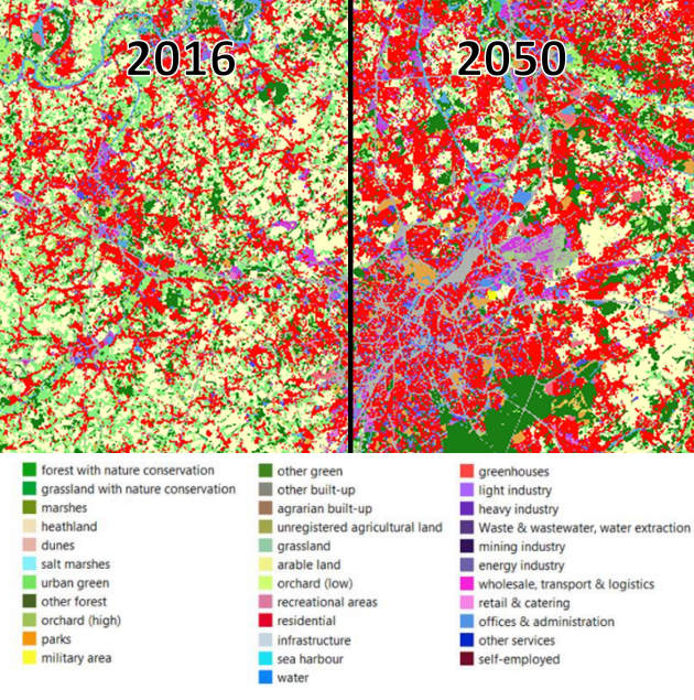
The results are quantitative translations (i.e. maps and figures) of imaginable futures from which various lessons can be drawn based on spatial indicators that, for example, calculate how many new buildings are expected in flood plains, how fast the degree of urbanization is increasing, how much open space will be lost, ... When significant differences occur in the results of alternative scenarios, these can form the basis of a policy that supports the transition to a more sustainable use of space.
Read more (in Dutch):
Steunpunt Ruimte en Wonen: De toekomst van de Vlaamse Ruimte in een veranderende wereld
Milieuverkenning 2030 (VMM) en de Natuurverkenning 2030 (INBO): De ruimte in Vlaanderen verkend: rapporten Landgebruikskaart en Verfijning RuimteModel